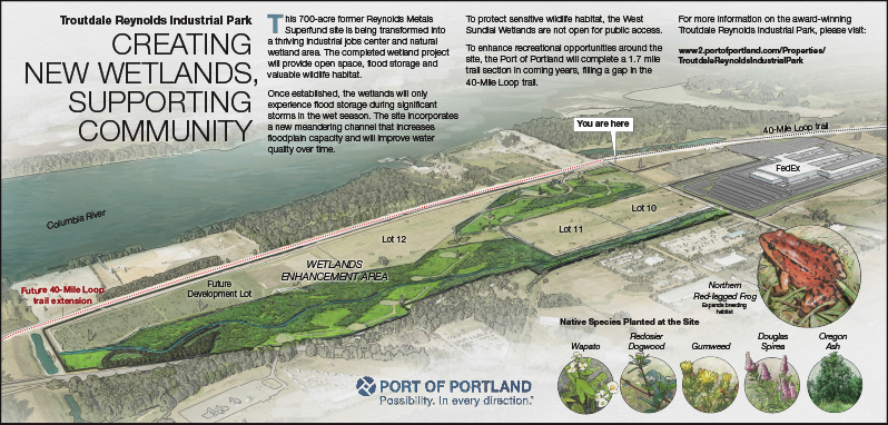
A new interpretive sign tells the story of wetlands at Troutdale Reynolds Industrial Park.
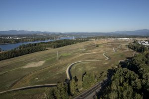
Earthwork that created a new meandering stream channel and lowlands were completed this summer by the Port of Portland, and native plantings are growing. The area is an active construction site through December 2016.
The sign is designed to help those using the 40-Mile Loop trail learn about the project and native species at the site, and includes a map of the wetlands. The sign is located off Northeast Sundial Road across from the trailhead. However, public access to the actual wetlands is not permitted. The area is designated for wildlife habitat and should not be disturbed.
Located at the confluence of the Sandy and Columbia rivers, the Troutdale Reynolds Industrial Park provides a unique opportunity for wetland creation and enhancement, along with challenges to restore a wetland in a dynamic, riparian environment.
The wetland enhancement project is a journey. 500,000 cubic yards of material was moved to form the Sundial channel and sculpt wetlands. To stabilize the site, the Port installed 152,000 square yards of coconut fiber matting over hydroseeded soil. Over 98,000 plants will be installed over the next two years, including 21 different native tree and shrub species. It will take two to three years for plantings to fully establish.
The 700-acre brownfield redevelopment site includes a combination of open space and industrial lots that will be home to future businesses and new wetland habitat as part of a mitigation plan. The plan consolidates small, isolated wetlands into a much larger wetland system with greater benefits to wildlife and water quality.
For more information about Troutdale Reynolds Industrial Park, please visit: http://www2.portofportland.com/Properties/TroutdaleReynoldsIndustrialPark